Science! It’s the primary reason we’re down here with Icefin. It’s one of the reasons McMurdo as a town exists. And it’s the reason why Antarctica is still (relatively) free of human excesses and interference. But what is it exactly, in our context?
The lab that Britney runs at Georgia Tech, the Planetary and Habitability Lab, is focused on planetary sciences and astrobiology, with a particular focus on icy bodies. Breaking that down a bit farther, “planetary sciences” refers to the study of planets, their moons, and the interactions between them and other bodies in the universe. “Astrobiology” is a relatively new field that focuses on the origin, distribution and evolution of life on Earth and off of it. Icy crusts are a good indicator for potential life due to heat generation within the planet that may create a liquid ocean underneath such a crust by melting some of the ice. We think that oceans are a good place to look for life, since that’s where life of Earth is posited to have started. Further, the ice-water boundary on Earth is a stronghold for life, being one of the most concentrated zone of life along columns of water thousands of meters between the atmosphere and the sea floor. Therefore, a planetary body with an icy crust is thought to be a good place to begin the search for life outside of Earth.
There are four bodies that our group tends to focus on:
- Ceres is an icy dwarf planet in the asteroid belt between Mars and Jupiter, the largest non-planet body within the orbit of Neptune. It consists of a rocky core with an icy crust, and possibly a water-based ocean underneath. Evidence of cryovolcanism (volcanoes that eject icy particulates and other volitiles, called cryomagma, rather than molten rock) and organic matter have been discovered as well. (Aside: “cryovolcansim” is a bit of a misnomer, since there is no melted matter being ejected. It is perhaps better to think of these structures as simply large vents to an internal ocean that allow for outgassing, perhaps a “cryogeyser”.)
- Enceladus is a tiny moon of Saturn, only 500km in diameter (a little larger than the distance between Atlanta and Savannah), that is also a rocky body covered in ice, theoretically with a small liquid ocean underneath at least part of it. It was one of the early examples of this “cryovolcanism” when Cassini found jets of water vapor and other gasses and particulates spewing from the southern hemisphere. Some of this returns to the planet as a form of precipitation, perhaps like snow, and some escapes, helping to form one of Saturn’s famous rings.
- Triton is a large moon of Neptune, so large it’s thought to have been a dwarf planet that was captured by Neptune’s gravity. It’s rocky core is surrounded by a surface of frozen nitrogen, water, and carbon dioxide. The heat generated from the geologic activity present on Triton (rare among moons, only Io and Enceladus are known to have this property) might be enough to keep some of the water in the crusted in a liquid state, i.e. as an ocean. Active eruptions have been observed as well, with Voyager 2 seeing plumes of nitrogen coming from the surface.
- Europa is an ice-covered moon of Jupiter, large for a moon but small for Jupiter, with what’s thought to be an approximately 80km deep ocean of liquid water surrounded by an ice crust of between 10-30km thick. This is the one that Icefin is most related to, and the one Britney is most excited about. At about 1500km in radius, is of similar size to Triton and Earth’s moon, and has a thin (tenuous) atmosphere that’s oxygen-based. Unlike Triton and Enceladus, Europa’s ocean is thought to be kept liquid by a process called “tidal flexing,” or “tidal heating,” which is the process of heating due to friction as water is tidally active (alternatively, by friction due to the deformation of a body due to tidal forces). In simpler terms, gravity of other planets and moons pulls the liquid on or within a moon or planet back and forth creating friction between the liquid and the solid body, which in turn generates heat. This tidal flexing is also though to move the ice sheets around in a similar fashion to plate tectonics here on Earth.
")
_(cropped)")


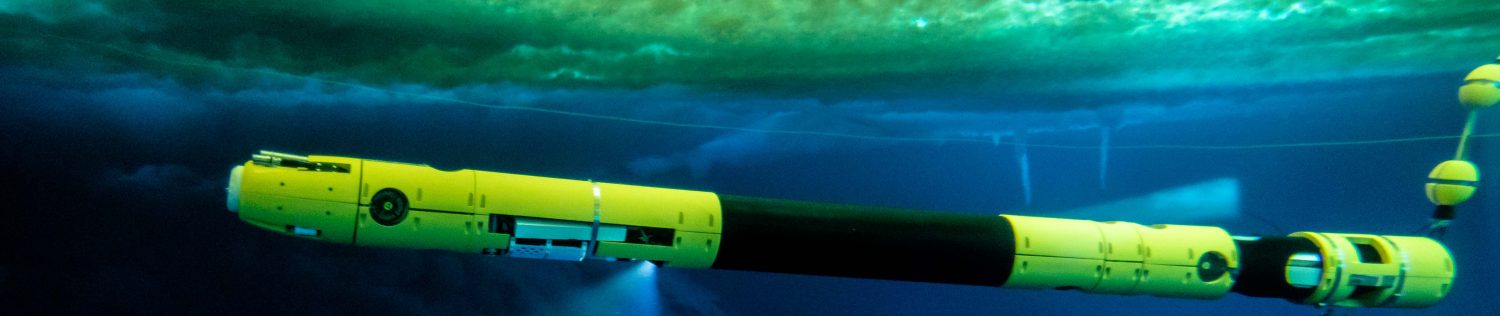
Planetary sciences and astrobiology are funny subjects in that a lot of the data tends to be from far away places, like celestial bodies, that take a very long time to get to (for reference, the Cassini spacecraft (RIP) was originally funded in 1989, launched in 1997, reached Jupiter in 2000, and was sent into Saturn in 2017). In order to make predictions about how these icy bodies we’re concerned with, we have to either assume that the ice acts completely differently than how we believe ice to act, that it acts completely the same, or some combination of the two. Either way, knowing how ice works here on Earth, and the processes around it, is an important mechanism for decision-making regarding future explorations to these icy worlds. Unfortunately (or fortunately, depending on your view), the mechanisms by which ice forms and interacts with its environment is one of the most under-studied and poorly understood systems in the world, and this is especially true down here in Antarctica. The Southern ocean that circles the continent is the major form of water transportation between all of the major ocean basins (the Atlantic, the Pacific, and the Indian), and the ice here, and processes regarding it and the Southern ocean, have a major impact on the climate, geological, chemical, and biological cycles that define our world. This is why Icefin exists: it can take oceanographic data to inform us about our world and potentially other worlds, all while also being a proving ground for a future under-ice vehicle that can be sent to the icy bodies we think may harbor life.
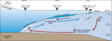
The movement of water masses around the ice shelf and sea ice, i.e. the oceanographic baseline we’re looking at.
So after all this, what science are we actually taking?
There are three main components to the data we’re interested in. The first is the oceanographic information: what is the topography in this region, how are water masses moving near and underneath the ice shelf itself, and how do these processes affect the dynamics of the ice. The second is chemical information: what is the distribution of known biologically-relevant chemicals and nutrients within the water column and ecosystem in this region. Finally, the third is biological information: what sorts of species, both microbial and bigger, are living in these ecosystems. Using these bits of data, we will be able to better predict the dynamics of icy planetary bodies, particularly Europa, as well as the potential for life on them.
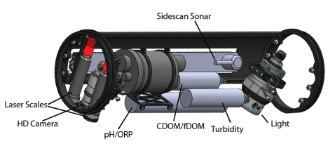
There are a number of oceanographic tools in a oceanographer’s arsenal, but the three most important ones are the pressure, the temperature, and the salinity of the water column. With these three data points alone, scientists can extrapolate a surprising amount of other important information about an underwater system. Conveniently, oceanographers have developed a single instrument that can take all of these data points called a CTD sensor, for Conductivity, Temperature, and Depth, where the conductivity can be converted into salinity, and depth can be converted into pressure. We have a handheld version of this tool that we call Cassini (in honor of the late spacecraft) that we are using to take measurements in single columns of water, and will use to both verify the data from Icefin and, perhaps more importantly, continue a multi-year effort to track the profiles of various water columns around the McMurdo area in an effort to monitor changes within the Ross Sea and its sea ice. The CTD casts, as they’re called, will help give scientists a better sense of how this local system works. These CTD casts are a relatively simple affair; they merely require the device and a reel (and often a weight to keep the sensor oriented correctly throughout the cast). Attach the sensor to the reel, lower at a constant rate until either the end of the reel or you reach the bottom, pause, and then raise at the same rate until Cassini returns home. This can nearly be done anywhere, and Britney, Justin, and Jade have been trekking out on snowmobiles and in the Pisten Bully to take measurements all over McMurdo Sound. Icefin has a CT sensor (no depth, we have a separate instrument for that) that will be used in conjunction with the CTD casts to create a much larger map of the oceanographic properties of the region. By taking this data, we can also look at how these measurements correlate with the currents around the area and how these dynamics affect ice conditions and biological ecosystems.
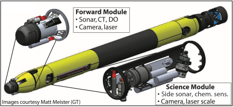
In addition to this, we also have two sonar systems, a current profiler (ADCP, Acoustic Doppler current profiler, located in the Navigation Module [not shown in the image]), and two camera systems to characterize the bathymetry (the underwater topography, or landscape) of the under-ice regions around McMurdo and the Ross Ice Shelf. The forward looking sonar is mostly for obstacle avoidance, as is the forward looking camera, but the other two are much more bathymetrically-relevant. The side-scan sonar looks out to the sides below the vehicle, seeing swaths of landscape up to 200 meters away, allowing us to swim long, straight patterns to document the topography. The pings it sends out bounce off various features and return at different times, allowing the software to distinguish pattern and shadows that can later be deciphered into actual maps. The downward facing camera helps when we’re close to the interface, where the side-scan sonar isn’t useful. It can give us high-definition close-up videos of these areas, allowing us to look closely at smaller features, plants, or animals, along our path. Icefin’s ability to hover is incredibly useful here; we can see something from far away with the sonar, get closer via the front camera, and then swim over for a detailed look with the down camera. Finally, the current profiler uses the doppler effect, similar to what happens when an ambulance’s siren changes pitch as it gets nearer and farther from you, to both calculate the vehicle’s speed and the speed of the surrounding water current. This can therefore be used as both an oceanographic data collection tool as well as a navigational instrument, giving us some sense of where we are and where we’re heading. Perhaps most importantly, the relevant modules can be rotated so that instead of, say, the down camera facing, down to the sea floor, it can face upwards towards the ice. This will be critical to mapping the sea-ice interface, when the sea floor will be too far away to be of interest.
The chemical information we’re concerned with the composition of the water itself: what kind of ions are in it, what sort of dissolved organics are present, and more. This sort of data will help us to map biologically-relevant features to various oceanographic processes and information. We have two tracks for getting this type of data. The first is in situ, meaning directly in the medium itself, also called putting sensors directly on Icefin. We have a few sensors currently on the vehicle for this:
- A pH sensor, which measures the acidity of the water
- An oxidation-reduction potential (ORP) sensor, which measures, in a sense, the “cleanliness” of the water, and is related to the amount of bacterial activity
- A dissolved oxygen (DO) sensor, which measures the amount of oxygen present in the water, which is related to how much life can be sustained
- A turbidity sensor, which measures the level of mixing within the column, and is related to how well nutrients and chemicals are moving up and down the water mass
- A dissolved organic matter (DOM) sensor, which measures the amount of dead or otherwise excreted organic material in the column, and is related to how much life is currently around.
These five sensors will give us a healthy amount of data to both look at the ecosystem in McMurdo Sound under the sea ice and underneath the Ross Ice Shelf itself, as well as using it to predict where we might find other communities in similar environments both terrestrially and elsewhere.
In addition to the in situ data collection, we are also going to be taking water samples directly from a variety of sites for lab analysis. For this, we use a special tool with a very prosaic name called a water sampler that, quite literally, is an empty chamber that is lowered to depth and then closed to capture a parcel of water. While simple, it’s very useful, and can be deployed with the CTD instrument as well, making day trips out to the sea ice a two-fer. Some of the water samples will be analyzed later in the lab for a variety of dissolved nutrients, including nitrogen-based and phosphorous-based species, which are further indicators of bacterial activities and conditions.
The remaining water samples will be filtered and later used for DNA extraction. This is one of our tools for the biological information we’re collecting to confirm the habitability of the ice shelf and sea ice regions. This DNA extraction will take place in Dr. Jennifer Glass’s lab back in Atlanta, which will be followed by genome sequencing to determine the bacterial makeup of the water in the area. This will give us definitive information about whether communities live here, which will tell us how habitable they are. These analyses will be supported by visual confirmation via our camera systems through which we can look for life in real-time on dives at a macro scale (meaning we can see it). We are also in the process of developing an in situ instrument to aid in this endeavor called the MicroBioChip, which will characterize the microbial diversity in these ecosystems by real-time cell counting and collection of samples for later processing.
Whew! That’s a lot of data!
(Sorry for the lack of pictures – sensors are not that interesting to look at, and the data is still mostly proprietary.)
Thankfully, Britney and Justin are data fanatics, and enjoy playing with it to find correlations and patterns, so they will have their work cut out for them as we start really collecting it – each of the short dives we’ve done so far has collected at least 10GB in log files and videos! It’ll take time to go through it all, so currently we’re focusing of making sure that Icefin and its sensors work as expected so that the data we get is all valid. So far, it’s looking good!
Thanks for reading!

Thank you for such a detailed, interesting and understandable explanation of what science Icefin is doing (and all of your team of course) how the data is being gathered and why that data is important and what you want to do with it. The instrucmnetation is amazing and just thinking about how Icefin had to be designed in order to accomplish all this is mind-blowing. Thanks for helping us really see and understand the science.
LikeLike
My pleasure! Glad you found it approachable!
LikeLike
Outstanding post! Thanks for sharing. Wish you had projects in AK!!!
Good luck with your field season.
LikeLike
CAC student here,
It is interesting to see how science has progressed in so many ways where we can actively visualize and set predictions for expected life on these other planets/moons. The study itself is very interesting and the other side of it would be getting the technology to the planet and potentially digging out the ice to see underneath where the ocean lies.Hopefully within the years to come there will be technology to accomplish this, aided with the studies you guys are doing in the field!
LikeLike